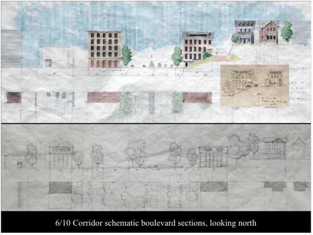
An illustrative board from the Notre Dame 6-10 presentation.
Here are the boards – images reflecting thoughts thus far – of the charrette or brainstorming session on the 6-10 connector and Route 195 land issues, hosted last month by Prof. Philip Bess and his graduate students from the School of Architecture at Notre Dame. This is part of Bess’s annual After Burnham studio on city planning. Coincidentally, as these boards were being released, the city of Providence released its own preliminary plan for a boulevard, sort of, to resolve the 6-10 aging problem. The Rhode Island Department of Transportation wants now, alas, to simply rebuild the connector as a 1950s-era limited-access highway.
After Governor Raimondo’s decision, I ran a post referring to the Notre Dame visit to Providence, “Build the boulevard anyway.”
To some degree, I suspect, the city’s plan for 6-10 is much closer to the Notre Dame plan for a 6-10 boulevard than the state’s rebuild plan. And the Notre Dame plan is closer than the city’s plan to a possible simpler boulevard plan, without bells and whistles (sort of like boulevards used to be back in the day before everything had to be ridiculously complicated). The simpler boulevard plan might address the speed-of-implementation (that is, safety) issues that are allegedly behind the state’s new plan to simply rebuild the awful raised highway originally built half a century ago.
I include a link to the Notre Dame boards thus far, showing progress toward reaching a proposal on 6-10 (and, to a lesser degree, on 195). I also include several links to the recently released city boulevard plan, with its “halo” intersection between 6 and 10. It is a lot of material, but worth going through. First, the Notre Dame link. Below are the several city links:
Draft Plan: http://bit.ly/2cPY8Ep
PDF of the presentation: http://bit.ly/2dO1ldE
Live Stream Video of the presentation: http://bit.ly/2d04ODf