
Partial view of the drop curtain at Rhode Island Historical Society. (Fox28Media.com)
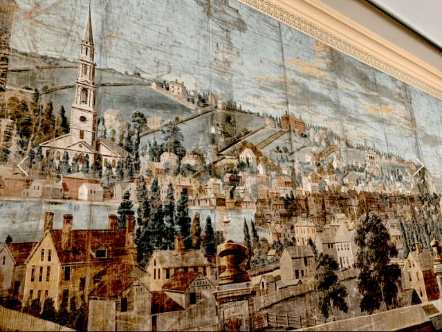
The Rhode Island Historical Society yesterday displayed its amazing 1809 drop curtain, owned by the society since 1833 and depicting the town as it appeared in 1808, twenty years before the Providence Arcade was built in 1828. It is thought to be the oldest curtain of its kind in America.
I dropped in to see it near the end of celebratory viewing hours of 1 p.m. to 5 p.m, and while I had long been familiar with its existence and had seen it in books on Providence history and architecture, one must see it in person to understand how fully it is charged with the energy of time and place.
John Worrall, a scenery painter and pantomime dancer at the first theater constructed in Providence, on the site of what is now Grace Church, seems to have daubed the curtain from a vantage point on Federal Hill. You can see the easterly edge of what was then still a residential area, the Providence River flowing beyond, and beyond that College Hill, then called “The Neck.” Brown University, founded in 1764, became Brown, named for the prominent family of donors, merely five years before the curtain was painted. University Hall, built soon after the college moved from Warren, R.I., to Providence in 1770, can be seen in the above image along a seam of the curtain, whose ten linen panels total 24 feet across and reach up 15 feet.
The curtain raises a number of questions for your architectural sleuth. For example, the road that proceeds downhill from University Hall (still called the College Edifice in 1809) must eventually have become College Street, at the bottom of which you’d think would be Weybosset Bridge, erected in 1663 and replaced five times before 1809. But the bridge cannot be seen, perhaps because it is behind a stand of trees on the near side of the river.
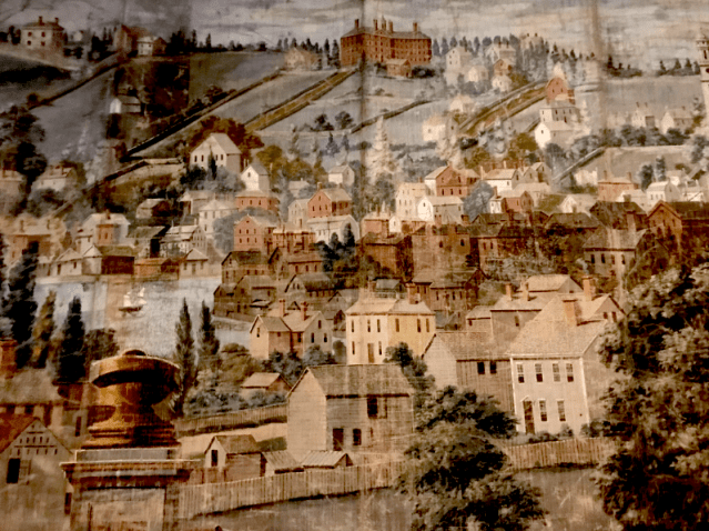
Where is it? The first image below is a closeup taken Thursday by me of that segment. It does not show in the minimal space between the trees. Perhaps the existence of the trees offered Worrall the opportunity not to paint the bridge. Or, perhaps, for the same reason, he painted in a stand of trees that did not exist. Hard to know, but fun to speculate! The bridge was destroyed seven years later in the Great Gale of 1815 and rebuilt twice as wide.
Or maybe the bridge that existed in 1808 is hidden behind houses along what seems to be the narrower southern stretch of the river, which seems to widen just right of the stand of trees. The six-map analysis of the changing banks of the river by John Hutchins Cady, which I discuss in Chapter 13, “The Widest Bridge in the World,” in my Lost Providence (2017), bears out that possibility. The third map in that progression shows the Cove (not the Cove Basin, built later on the Woonasquatucket River). So it was indeed those houses that excused Worrall from painting the bridge. Brilliant deduction, Sherlock!
(I have taken the liberty of enhancing the contrast of the images above and below. The conservation of the curtain, by Curtains Without Borders, did not attempt to erase the dimming effect of time but to fill in imagery rubbed by folding and wear, mostly along the seams of the panels. Marvelous as it is, this was not, after all, the restoration of Michaelangelo’s Sistine Chapel.)
It looks as if the western embankment of the river, nearest the observer, is more densely occupied than College Hill itself. Of course, unlike on College Hill, most of the early structures on the Weybosset Neck were torn down and replaced, maybe once or twice or more, by the structures that now make up today’s downtown. Some of the houses on the west side of College Hill that were there in 1808 still exist today. No doubt a few are on the curtain. It is hard to know whether the houses painted onto the far side of the river are accurate or artistic renderings of what houses there were like in 1808, so that Worrall could generalize the appearance of each house he drew. The truth is probably somewhere in between. It is even harder to ascertain the accuracy of the houses on the near side of the river, since they are certainly all gone.
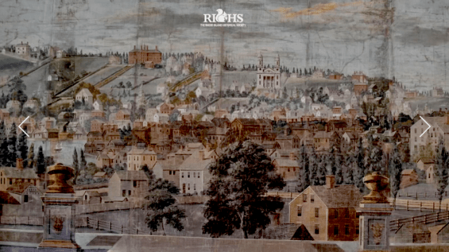
If I come across an analysis of the drop curtain’s depiction of Providence that answers some of these questions, I will report dutifully to the readership. In the meantime, feel free to speculate based on the images above and below – better yet, visit the RIHS at Aldrich House, 110 Benevolent St. – and I will be glad to publish the most interesting speculations. (Below, the first three images proceed from north to south, with the fourth about three-quarters of the view, mostly to the north, and the last most of the view, including most of the southern portion, photographed by the RIHS.)


Stunning depiction of a stunning city…
LikeLike
Actually, Steve, Providence was a town and was not incorporated as a city until 1832, I think it was. But I am just joshing you. I probably have referred to Providence as a city before that date myself.
LikeLike
Yes…1831. Just using “city” generically.
City or town – stunningly beautiful.
LikeLike
The twin spired church in several of your pictures is the second Meeting House of First Congregational, (now First Unitarian). It was built in 1795, and burned in 1814. I assume the brick house with 4 chimneys to its right is the John Brown House.
LikeLike
Yes, Peter, I was once married in that church, that is, the church with one spire not two.
LikeLike
Thanks for writing about this marvelous curtain, David.
LikeLike
I assure you, Ed, the pleasure was mine!
LikeLike