
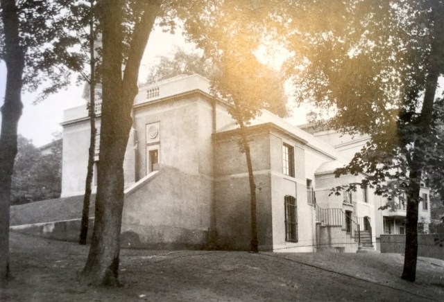
“This is a rear view of the Shepley Library at 292 Benefit Street. [Historian] Margaret Stillwell … recalls that just beyond the John Brown House stood a ‘little building put up by Colonel George Shepley to house his collection of Rhode Island books, prints, and manuscripts'” (Providence’s Benefit Street)
The revelation that such a library existed raises numerous questions. When was it built? When was it lost? Was another house demolished to make way for the library? The caption to another shot of the library reads: “The image below, undated, shows the front of the Shepley Library at 292 Benefit Street.”
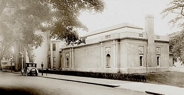
The database text for the same image in the online archive of the Providence Public Library reads: “Image shows the Shepley Library on Benefit Street. The library appears to be an addition built onto the Shepley House. A car is parked outside the library. Library no longer stands” The detail below of my 1895 plat map of the southern portion of College Hill and Fox Point shows a house at the sharp corner of the block that may be the library, with the Shepley House (the colonel’s residence) just above it along Charlesfield. If so, and if the front is indeed on Benefit, then it is hard to tell how the Shepley House fits to its left in the photo above.
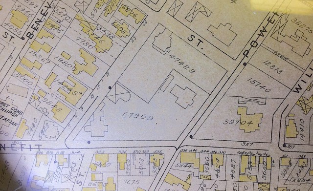
Of course, the map or the book may be wrong, or I may be incorrect in my belief that the map is from 1895. If so, the footprint that looks like it may be the Shepley Library might also be a house that could have been razed to build the library. Or maybe it is the library but the mapmakers got the footprint wrong, or maybe the library underwent renovations that changed the shape of its footprint.
Other buildings that I perhaps ought to have included in Lost Providence include the city’s first train station, designed by Thomas Tefft, from 1848, and the Hospital Trust Bank Building, completed in 1891. The lifespan and location of each are considerably less indeterminate than those of the Shepley Library. No doubt also my investigation into the library represents a regrettably limited effort of sleuthery by the author of Lost Providence. I hope someone will provide additional (and more reliable) information – perhaps during my evening at the John Brown House on Thursday. I look forward to writing a more satisfying addendum to this report.
[The day after uploading this post I published “Shepley Library addendum,” which updates readers on the former library’s actual location.]

Isn’t the map a Sanborn Fire Insurance Map down to the fonts and, apparently, yellow for frame structures? All the maps are now online for various dates in each city.
LikeLike
I’m not sure, David, maybe so. I have more than half a dozen of them of Providence, nicely framed and leaning against a wall in my house’s basement, yearning for the days when they hung on the walls in my loft downtown, overlooking City Hall and Kennedy Plaza (Exchange Place when these maps were made). I will see if I can find them online. Many thanks.
LikeLike
The Shepley house still stands at 292 Benefit Street, opposite First Unitarian ( “First Cong. Church Unitarian” on your map). The back view is looking up towards Benefit, and the street view is from Benefit and Benevolent. The location of the library is now a parking lot.
LikeLike
I think you nailed it, Peter. See my post tonight (not yet posted).
LikeLike
David,
I think the upper photo is the view from Benefit Street. It corresponds to the map orientation and the topography of the John Brown Housev property. The lower photo shows the Sheply house just beyond on Charlesfield.
LikeLike
Yes, Eric, that also struck me as a possible explanation for the incongruities I noticed, including that the topography of the photos didn’t seem to match the idea that the library fronted on Benefit Street rather than Charlesfield. That the library has a Benefit Street address argues against that view, but it is not dispositive.
LikeLike